News

Entry Thumbnail

About the Basin: Gravelly Point

Gravelly Point Park

About the Basin—August 24, 2018

A little boy watches a large plane fly directly overhead. Gravelly Point Park is a favorite spot for kids of all ages for one main reason: the love of airplanes. The park is known for being one of the best places for plane spotting in the nation. The grassy strip of land is located just north of Ronald Reagan Washington National Airport in Arlington, Va. and just a few hundred yards from their runways. With your feet planted firmly on the ground, it feels like your fingers could graze the bottom of the Boeing 747’s passing just above your head. The view of the underside of the planes is only complemented by the stunning skyline of our nation’s capital just across the Potomac River.

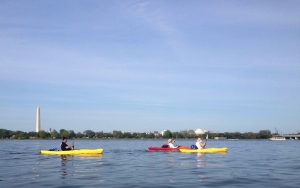
Launch a boat from the ramp at Gravelly Point to get an even closer look at these flying behemoths. The strip of water that leads from the ramp to the Potomac River is located directly between the runway and Gravelly Park. Paddle across the Potomac River for a new perspective of D.C.’s famous monuments and a close-up look at the bridges that span the river.

Gravelly Point is located alongside the 18-mile Mount Vernon Trail, which runs from Theodore Roosevelt Island to George Washington’s Mount Vernon Estate. This trail is a favorite of bicyclists, runners, and walkers for its smooth surface and beautiful views. The rocky shoreline is a prime spot for anglers.

Three kayakers in the Potomac river in front of D.C. monuments

Kayaking on the Potomac River

It gets busy on weekends, so come early to find a parking spot or use the Mount Vernon Trail for access. Please note that the park is only accessible while traveling north on the George Washington Parkway. Bring a picnic because there are limited amenities.

Entry Thumbnail

About the Basin: The Tidal Basin

How the Potomac Flats became the Tidal Basin

Sunrise at the Tidal Basin, Washington, D.C.

Photo Credit: Flickr, christophersmith29

About the Basin – August 17, 2018

The Tidal Basin in Washington, D.C. is probably most notable for its breathtaking cherry trees that drip soft pink blossoms into the water as spring emerges. However, there is more to this appendage of the Potomac River than meets the eye.

In the mid-1800’s, commerce in the popular shipping ports in the District was hampered by silt build-up along the shores. It was also a health issue. The silt build-up, known as Potomac Flats, sat with stagnant raw sewage and was a breeding ground for malaria-laden mosquitoes.

Authorities decided something needed to be done with this unhealthy eyesore in the Nation’s capital.  Congress agreed it should be enjoyed by the people of the city, ordering it as “forever held and used as a park for the recreation and pleasure of people.”

Around the turn of the century, the U.S. Army Corps of Engineers (USACE) developed a plan to dredge the river, create the Washington Channel (the stream of water that runs through the basin and then between Potomac Park and the mainland), and dump the dredged silt onto the remaining part of Potomac Flats. This created the East Potomac Park portion of the basin and the modern shape of the Tidal Basin that we all know and love.

A map of the Tidal Basin in Washington, D.C.

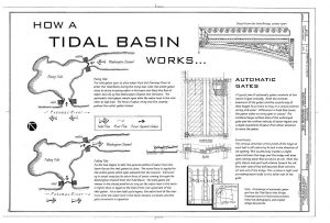
To keep silt, raw sewage, and other unwanted problems from building up, USACE installed a gate at each entrance of the basin. During high tide, the gate at the river allows water to enter the basin while the gate at the channel closes, filling the basin. As the tide ebbs, the gate to the Washington Channel opens while the gate at the Potomac River closes. Silt and other pollutants quickly drain through the channel. The Library of Congress has some diagrams of how the Tidal Basin functions to prevents stagnation and all the problems that come with it, such as algae growth, funky smells, and silt build-up.

This engineering marvel ensures that visitors from around the corner and around the world can enjoy the beautiful sites of the Tidal Basin. The Franklin Delano Roosevelt Memorial, the Martin Luther King, Jr. Memorial, and the Thomas Jefferson Memorial can all be seen along the 2-mile loop around the basin. Walking and running along basin trails are popular activities for both locals and tourists alike. Pedal boats, available for rent, can provide a unique perspective of the natural beauty in this wholly man-made structure.

A diagram of the gates in the Potomac Tidal Basin, Washington, D.C.

Library of Congress, Call Number HAER DC,WASH,574-
 

Entry Thumbnail

About the Basin: Cunningham Falls State Park

Cunningham Falls State Park

About the Basin, August 10, 2018

A sign in front of a boardwalk that looks over the Cunningham Falls. The sign talks about water quality. Cunningham Falls State Park, near Thurmont, Maryland, has many treasures. It is known for being the largest cascading waterfall in Maryland. Big Hunting Creek, one of Maryland’s premier trout streams, runs through the park.  Swimming in the lake is a summertime tradition for many families, both near and far.

The park has many miles of beautiful hiking trails, but the most popular trail is the short, forested hike to the falls. It is stroller-friendly and great for all ages. The falls have a viewing boardwalk with benches. After enjoying the falls, head back down to lake, grab a picnic table, spread your towel on the sand and spend the rest of the day enjoying food, friends, and family while cooling off in the lake. Grills are available on a first-come first-served basis.

Check out the park map to find some primo catch-and-release fishing spots in the park.

The park is separated into two sections, the William Houck Area and the Manor Area. Check your GPS carefully before heading out to make sure you are headed to the correct area for your intended adventure. Both areas have a campground.

William Houck AreaThe waterfall at Cunningham Falls State Park

This area has the hike to the falls, the swimming lake, and a concession stand that is open during the summer.

Come early on nice weekends because the park will temporarily close when they meet capacity.

Manor Area

Visit the Scales and Tales Aviary for an opportunity to get a close-up look at (mostly native) wildlife.

The Catoctin Mountain Furnace features a furnace that began operations around 1776. The furnace provided ammunition for the Continental Army during the American Revolutionary War.

Join park staff this Sunday, August 12, for Macroinvertebrate Mayhem (11am, South Beach Nature Center) where staff will lead a walk through a stream to discover what creatures live just below the surface.

Entry Thumbnail

ICPRB Publishes the Potomac River Basin Comprehensive Water Resources Plan

One Basin, One Future: ICPRB Promotes a Sustainable Water Future

New report addresses water resources in the Potomac River basin for today, tomorrow, and the future.

The Interstate Commission on the Potomac River Basin is proud to announce the publication of the Potomac River Basin Comprehensive Water Resources Plan.  The Plan addresses issues of ensuring reliable drinking water supplies, improving water quality and ecological health, and sustainable land use management as it relates to water resources.  It was compiled using a collaborative process that engaged diverse stakeholders that included representatives from different levels of government, regions of the basin, water use sectors, and nongovernmental organizations, and it recommends actions that each stakeholder group can take.

The Plan builds on existing state and local efforts and is intended to complement those efforts by paying particular attention to water resource issues of interstate- and/or basin-wide significance.  It serves as a guide to the status of water resources in the basin and provides a basis for deciding how the needs of one water use can be accommodated while still providing for other uses.  The report’s recommendations include greater information sharing, improved data collection, greater coordination among user groups, and identification of common goals.

The ICPRB will use the Plan to set priorities for its activities in coming years and hopes those activities will be a catalyst for the Plan’s implementation in collaboration with other stakeholders and the public.  Looking ahead, ICPRB expects to periodically evaluate basin wide progress toward a vision of the Potomac River basin as a national model for water resources management that fulfills human and ecological needs for current and future generations.

The comprehensive planning effort was partially built on nearly five decades of experience working with Washington Metropolitan Area water suppliers to provide a safe, reliable water supply system for the region during extreme droughts without stressing the Potomac River, the major source of drinking water. The successful system has been continually enhanced through regular studies of demand, alternative water sources, threats to source water, and possible effects of climate change on the system. These experiences in cooperative research and decision-making have informed the water resources comprehensive plan.

“The Potomac basin has a history of collaborative efforts among the basin states. The Potomac River Basin Comprehensive Water Resources Plan can serve as a common platform for analyzing and prioritizing the efforts that can serve the public’s many interests while preserving the resource into the future,” said ICPRB Executive Director Carlton Haywood.


Entry Thumbnail

About the Basin: The Black Panther on the Bottom of the Potomac

The Black Panther on the Bottom of the Potomac

About the Basin

A Photo of the top of U-1105, the Black Panther

Photo Credit: Maryland Historical Trust

For 69 years a German submarine, known as U-1105, has sat at the bottom of the Potomac River.

Commissioned in June 1944, the submarine lived a short but eventful life. Serving as a wartime patrol near Ireland, it killed 32 men while disabling the British HMS Redmill. Less than a year later, Germany surrendered. The war was over.

U-1105 became a spoil of war as it was valuable for research and testing purposes. Nicknamed the Black Panther due to its “skin” of black synthetic rubber meant to evade sonar devices, the U.S. Navy soon acquired it to conduct research. Only a few years later the submarine took a 20-second trip to the abyss.

It remained forgotten in its watery grave for the next 40 years. Rediscovered in the 1980’s, the shipwreck site just off Piney Point, Maryland, soon became Maryland’s first historic shipwreck preserve and it is now part of NOAA’s National System of Marine Protected Areas.

Although the submarine is a tourist attraction for civilian divers, at 91 feet below the surface, it is considered a highly technical dive with a strong current and low visibility. For armchair adventurers, a video of the Black Panther is available on YouTube.

It is just one of several submarines with intriguing stories found on the bottom of the Chesapeake Bay and its rivers. Learn more about the fascinating history of the Black Panther on the Maryland Historical Trust website.

Entry Thumbnail

About the Basin, Peculiar Potomac Edition: Waffle Rock

Waffle Rock

About the Basin, Peculiar Potomac Edition

A large rock with a waffle-like pattern on one side. Photo Credit: mdmarkus66, https://flic.kr/p/7WFfUy

Photo Credit: mdmarkus66, https://flic.kr/p/7WFfUy

Last week’s About the Basin covered the Jennings Randolph Lake near Elk Garden, West Virginia. This week’s article takes a closer look at a geological phenomenon known as Waffle Rock. This interesting rock stands guard at the West Virginia Overlook above Jennings Randolph Lake.

This massive rock has a large waffle-pattern on one side. Some have claimed it is evidence of visitors from another planet, some say it is the scale pattern of a ginormous lizard, and others say it is just an interesting geological formation. We’re going with the “geological formation” theory.

Several hundred million years ago, according to ICPRB hydrogeologist, Jim Palmer, “Joints opened up in the soft sandstone and allowed iron rich water to seep into cracks and form cement around sand particles.” This cemented sand is highly weather resistant. Regular sandstone is not. The soft sandstone eroded away from the rock while the grid-like pattern of the hard sandstone remained, creating a waffle-y rock.

The rock was originally part of a larger formation that broke off some point in the past few hundred million years. It ended up near Shaw, West Virginia, the ill-fated town that is now at the bottom of Jennings Randolph Lake. The rock had geological (and, according to the story, sentimental) value. Before the lake was filled in during the early 1980’s, the rock was moved to its final resting place. It now welcomes tourists and locals alike to ponder the deeper things in life while overlooking the scenic Jennings Randolph Lake.

Entry Thumbnail

About the Basin: Jennings Randolph Lake

Jennings Randolph Lake

Less than 3 hours west of the Washington metropolitan area lies a massive man-made lake with a storied past. Tucked into the Allegany Mountains of West Virginia, Jennings Randolph Lake sits over land that was once a small town called Shaw. In 1981, the residents moved out and water moved in.

As part of the North Branch of the Potomac River, these are the source waters for the 5.1 million people in the Washington metropolitan area. In times of drought, the lake serves as an emergency reservoir to many downstream. In addition to water supply, the project was constructed for flood risk management, water quality, low flow augmentation, and recreational opportunities. The dam was constructed, and is still managed by, the U.S. Army Corps of Engineers (USACE).

But Jennings Randolph is more than just a place to store water for thirsty people downstream. The 4,500 acres of land and water is a recreational hub with an impressive variety of activities. These include boating, camping, waterskiing, scuba-diving, hiking, swimming, archery, birding, hunting, whitewater rafting, and record-breaking fishing.

Walleye is regularly stocked in Jennings Randolph. Patience is required though, as they are known for being large, but also wily and difficult to find in the lake. Smallmouth bass, trout, bluegill, and catfish abound.

The Howell Run Picnic Area is a picturesque picnic spot overlooking the lake. It offers several shelters for rent, many picnic tables, trails, bathrooms, fishing, and more.

A trail from the picnic area leads to a swimming spot known as Shaw Beach. This sandy beach is a great place to soak up the rays while the kids play in the water.

A 3D archery course is available if you are looking for more adventures. The course is for both beginners and advanced shooters, but you will need to bring your own bow.

During the spring (and occasionally during the summer), USACE releases enough water from the dam to make Class I, II, and III rapids in an area below the dam known as Barnum Whitewater Area. The release schedule for the year is posted online.

Whether you are looking for a day on the water, a day on the beach, or even bigger adventures, Jennings Randolph Lake has something for everyone.

Entry Thumbnail

About the Basin: Fairfax Stone State Park

Fairfax Stone State Park

A white, aged plaque that tells the story of Fairfax Stone.

Photo by West Virginia State Parks

Fairfax Stone State Park, near Davis, West Virginia, has no boating, no hiking, and no camping. It does not even have a restroom. In fact, it is a diminutive 4-acre park.  However, it has immense importance to the Potomac River and the history of the region.

A spring, marked by an organized pile of mossy rocks, is the beginning of the North Branch of the Potomac River. A mere 383 miles downriver, that trickle transforms into the 11-mile wide mouth of the Potomac River, spilling into the Chesapeake Bay.

Before the American Revolution, it was the tradition that English kings would reward loyal friends with large parcels of land in the territories. A plaque on a six-ton rock at the entrance of the park commemorates the western boundary of land granted to Lord Fairfax by King Charles II of England in 1746.

A large stone with a plaque that tells the story of Fairfax Stone.

Photo by West Virginia State Parks

His bounty was, “bounded by and within the heads of the Rivers Rappahannock and Patawomecke”. Known as Fairfax Stone, it is one of the oldest markers in the United States. This plot of land has been part of many boundary disputes.

There may not be many amenities in this charming park, but it is a good reminder that even the largest rivers start as a trickle.

Camping and other amenities can be found at the nearby Canaan Valley Resort State Park and Blackwater Falls State Park.


Photo of a map showing the Fairfax Stone state park in the west and Washington, D.C. in the east.

Photo from Google maps.

Entry Thumbnail

About the Basin: Brunswick Family Campground

Brunswick Family Campground

Four kayakers are seen from behind as they paddle down the Potomac River near Brunswick, Md.

Kayakers paddle down the Potomac River from the Brunswick Family Campground boat ramp.

For many families, the Brunswick Family Campground in Brunswick, Maryland is a summertime tradition. Whether you are a hiker, biker, kayaker, history buff, or train enthusiast, there is something for everyone at this campground along the C&O Canal Park.

This campground is known for two things: access to the river and trains. Campers launch from the boat ramp for a paddle down the Potomac River. Organize boat rentals and transportation with camp staff. Some campers park their beach chair in the shallow waters along the edge to cool-off on a hot day.

Train enthusiasts can enjoy the trains that come rumbling down the tracks along the campground throughout the day. Don’t forget your earplugs for the nighttime rumbles! Learn more about the town’s rich transportation history at the Brunswick Heritage Museum.

Plan to spend a few days exploring the area. The historical powerhouses, Harpers Ferry National Park, Antietam National Park, and Monocacy National Battlefield are all an easy drive from the campground.

One of the perks of staying at a campground managed by River & Trail Outfitters is that many of their boating trips launch directly from the boat ramp at the campground. They offer a variety of adventures along the Potomac River, including an upcoming Sunset Float and Moonrise Paddle Tour on July 21. We would like to thank River & Trail Outfitters for their help as “river watchers” for ICPRB’s weekly newsletter, River Watch.

Going out on the Potomac River this weekend? Show us how much you love the Potomac by using #PotomacLove in your social media posts!

Entry Thumbnail

About the Basin, Peculiar Potomac Edition: Foamhenge

Foamhenge

Several large blocks of foam backlit by the sun. They are arranged to look like Stonehenge.

Foamhenge at Cox Farms

In celebration of the beginning of summer, this week’s About the Basin covers an internationally known pile of rocks that honors the summer solstice.  No, not Stonehenge, but the lesser known -henge this side of the pond: Foamhenge.

At Foamhenge, the life-size blocks of foam are chiseled, painted, and arranged to be an exact replica of the slightly-more-famous prehistoric wonder of the world, Stonehenge, in Wiltshire, England. However, this one is closer to home.

Located at Cox Farms, Foamhenge is less than an hour’s drive from the D.C. Metro Area. This homage to Stonehenge is open to the public on Saturdays (12:00-2:00pm) during the summer and spring seasons. Admission to this quintessential American roadside attraction is free but only accessible via a shuttle provided by the farm. Part of the weekly event called “Smokin’ Saturdays”, farm activities also include food, feeding farm animals, produce, and live music. Over-sized games of Yahtzee, Jenga, Connect 4, and Checkers are also available for entertaining the whole family.  This weekend, check out Foamhenge for a European-style staycation and marvel at the wonders that the Potomac basin have to offer right here at home.